Blog 3. June 20th to July 9th, 2019.
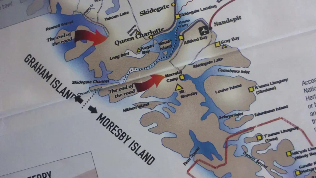
I closed my last blog by stating that we hoped to continue our cruise on June 20th. However, in a praiseworthy abundance of caution – given that we are heading for an area entirely devoid of facilities and communication – the doctor recommends waiting for the results of another check on June 24th. This is five days away and, rather than simply occupying limited space at the marina, we decide to attempt transit of Skidegate Narrows which divides Graham Island to the north from Moresby Island to the south. The narrows are very important for, without them, to pass from the eastern coast of Haida Gwaii to the western would mean a long and potentially hazardous journey all the way around either the top or bottom of the archipelago. However, the channel is winding, narrow in places, and subject to strong currents with the tidal range at the western entrance significantly less than that at the east. The invaluable Douglas cruising guide has this advice before attempting transit:
“You must feel comfortable in risky situations requiring high performance and be willing to make your own judgements”.
With this in mind we leave the dock at 0945 on a lovely morning on June 20th. It was good to be underway again. We anchor in Christie Bay and spot a raccoon walking along the beach.
June 21st Friday
The Summer Solstice is marked by another lovely morning. We wait for high tide before approaching the entrance to Skidegate Narrows. The channel is well defined with a series of markers to be left to port and starboard as well as several ranges defining the course to be followed between those markers. I take a photo as we enter the starting gate and it shows 12 beacons. The transit of the east and west narrows takes less than one hour, and we anchor in Armentieres Channel.
June 22nd Saturday
We spot another raccoon and a couple of deer on the beach. We decide to head out to sea to Marble Island which is reputed to be a seabird sanctuary. The sea is quite rough during our circumnavigation of the island. We see very few birds. Many small charter fishing boats out of Queen Charlotte cluster along the shore. We do a drive-by of Tanu Bay on the coast of Graham Island where basalt pillars soar skyward from the rugged shore. After this short expedition to the west coast we head back for a return trip through Skidegate Narrows and are anchored back in Christie Bay at 1803.
June 23rd Sunday
We are underway at 1018 from Christie Bay and arrive at Queen Charlotte dock at 1105. We spend a relaxed day, in my case mostly dedicated to backed up photos and video and bringing my journal up to date. A guy who lives in Alaska and who had watched my Dutch Harbor video recognized Venture and stopped by for a chat. He told us about a Lituya-type gravity wave and land slide which, as recently as October 17th 2015, created a monster gravity wave in Taan Bay off Icy Bay. The displaced water generated a wave which sheared alders more than 500 feet up on a hillside across from the slide. Amazingly, the Icy Bay landslide displaced substantially more rock and soil than the massive Lituya event but the Lituya wave was larger because it fell from a higher elevation into deeper water. Fortunately, being late in the season, no boats were in Taan Bay during that event.
June 24th Monday
Louisa and I walk up to hospital and consult the doctor again after another EKG. Happily, he feels the problem is sufficiently under control for us to continue our trip. Christine and Louisa embark on another round of provisioning. In the evening we go to dinner at the house of a couple who, provide quality evening meals for customers who have made reservations in advance. Diane and Jeff King provide an excellent meal and can be contacted at: diningatthekings@gmail.com
June 25th Tuesday
Unforeseen circumstances having thrown a wrench into our plans, we finally get underway to continue our trip. In our case it is not so bad because we never really know where we’re going until we’re there! We are underway at 1125. As a good omen, after rain every day, it is a truly beautiful morning under a cloudless sky. When leaving Sidegate harbour it is necessary to head north even when the desired direction of travel is south. A shoal extends a long way out from Sandspit and what appears to be a navigable piece of water conceals treacherous shoals. The sea is calm although the wind gradually increases to 15 kts but it is from north so is from aft. Fine weather, cumulus clouds hang like cotton balls over the green islands. Shortly after we anchor at in Rockfish Harbour on Louise Island at 1648, we notice sailboat Arestina on the AIS. This is the sailboat that was tied up ahead of us in Queen Charlotte marina. The owner, Mike Duff, was brought up in what was then Southern Rhodesia (now Zimbabwe) so we had experiences in common. We invite him and his fellow crew member to come over for drinks after dinner.
June 26th Wednesday
Another gorgeous day without a cloud in the sky. We do some drone flying this morning before we leave. Many small jellyfish drift around the boat. We hope that none get sucked into the genset raw water intake. Underway at 1022. Beautiful scenery but hillsides still bear the wounds of clear-cut logging. The steep slopes are also scarred by numerous landslides as well as wreckage of blowdowns caused by ferocious winds. We anchor at the extreme head of Crescent Inlet at 1325. This is an amazing area. In the grassy meadow at head of bay we see as many as six deer grazing on grass alongside six black bears. Also a pair of huge Sandhill Cranes (46″ high with 7′ wingspan) accompanied by one young bird. We go for a run in the tender and come across a sunfish (aka Mola Mola) which grow to an immense size. After dinner, when tide is higher, we take the tender towards shore but the bears show signs of unease and we immediately back off. We spot a flock of Merganser ducks on a fallen log. Also a Barrow’s Goldeneye duck. We watch a pair of Mews Gulls perched precariously on a sunken log encrusted with mussels.
June 27th Thursday
Another stunning morning with the same selection of wildlife on shore. We are underway at 1057 and cross into the Gwaii Haanas National Park Reserve for which it is necessary to have a permit for the boat and a pass for every person on board to prove they have attended a mandatory orientation programme. High altitude clouds begin to show but don’t seem to last. We go down Darwin Channel leaving Lyell Island to port which was the site of protests against the logging companies in 1985 by courageous tribal elders who were jailed for their actions. The protests ultimately led to the end of wholesale logging and Haida cultural revitalization of the islands. We saw no signs of recent logging in Gwaii Hanaas but the trees are in bad shape with many dead. We turn into De La Beche Inlet and anchor in La Sac inlet. We can hear running water from two streams fed from their own lakes. We enjoy dinner on the flybridge which is interrupted by a loud strange noise which turns out to be a very vocal sea lion circling Venture and clearly objecting to our presence.
June 28th Friday
We awake to rain. We are underway at 1012. The weather improves during the day and morphs into a lovely sunny afternoon. We have a bumpy ride around Scudder Point on Burnaby Island. We see the black and white cruise boat Cascadia and also a nice schooner Maple Leaf. We anchor at 1333 in Bag Harbour just to the south of Burnaby Narrows and launch the large tender for a tour of the narrows which the guide books say are alive with inter-tidal wildlife. Sadly, we are disappointed and do not see much of special interest. At 5.15 we make a second attempt when tide is lower. We see are enormous quantities of empty clam shells and many strange-looking Moon Snail egg casings. These last are predators of shellfish and we wonder if they are responsible for the lack of wildlife. We do not see any sea stars or anemones. Other small tenders arrive from the schooner Maple Leaf which is anchored just north of Burnaby Strait. We do not hear much about the bark beetle these days, but we wonder whether these pests – moving north with the warming climate – are responsible for there being so many dead trees protruding like bone-white specters from their living brethren.
June 29th Saturday
Underway at 0945. Overcast. We pass a schooner, Passing Cloud, heading south. As Hecate Strait is in a rare state of calm we decide to continue south to the remote Karouard Islands. It is rare to experience weather conditions making it possible to visit this isolated collection of rocky islets. Here we see puffins, cormorants, eagles and gulls. Over 600 breeding Stellar sea lions use the Cape James rookery in this archipelago – very noisy and smelly! After a brief visit we head back north and anchor in Heater Harbour at 1622.
June 30th Sunday
Underway at 0955. We go to Rose Harbour but just do a slow drive by. There is nothing much to be seen from water except a couple of rusting boilers. This was a major whaling station at one time. It was opened in 1910 and closed down in 1942 during which period it was responsible for processing 2,000 whales. We continue on to Anthony Island – now reverted to its original name of SGang Gwaay – where we arrive at 1145. We anchor off south beach and call the watchman on the VHF. We are requested to wait one hour and then walk to their house along the trail. After a quick lunch on board, we take the small tender ashore. Chris returns to Venture while the three of us walk to the old village site marked by decaying totems. Christine continues on to the Watchman house and returns with a young woman who is to be our Haida guide. She explains the significance of the remaining totems and other village features. We walk through the results of a massive blow-down which felled numerous trees on one night during the past winter. We return to the beach and Chris takes a quick tour of the village site. This far south, the east and west coasts of Haida Gwaii come together and, with the gift of rare calm waters, we decide to head north up the west coast. We get underway at 1441. We see glimpses of many whales but none very close. Mist and low cloud shroud the coast. We anchor in Yakulanas Bay off Gawgaia Bay at 1750.
July 1st Monday
Overcast morning. We see another two Sandhill Cranes on the beach at very low tide. Up anchor at 0945. Once outside in the ocean, visibility is very restricted and we can see neither land nor horizon. The mist slowly dissipates until we can see both. The coast is exceptionally rugged. Again we see glimpses of numerous whales. Well ahead of us we spot a pair of humpbacks breaching and tail slapping. Unfortunately, they have stopped their antics by time we reach them. We pass several inlets penetrating the land but there are no soundings within them or even close to the coast. There is almost zero wind but tide against current produces abrupt, close-spaced waves resulting in an uncomfortable ride. At 1310, we enter dramatic Tasu Narrows which opens into vast Tasu Sound. The mountain overlooking Hunger Harbour has been horribly defaced by the remains of a huge opencast mining operation which operated for 60 years from around 1923 to 1983 producing iron, copper and small amounts of silver and gold. We turn into Botany Inlet – one of several deep inlets leading off of Tasu Sound. We spot a black bear on shore partway down the inlet. When we anchor at its head, we see another bear and two black tail deer – one accompanied by two fawn.
July 2nd Tuesday
Low overcast in the morning. We see six deer in the grass and on the beach including a doe with one fawn grazing on the grass at the head of the inlet. At one point two black bears also share the same grassy meadow. One bear is almost alongside a deer. The doe with nursing fawn appears to be completely unconcerned by the close proximity of bears. The accompanying photo is poor quality but sufficient to show bear and deer in close proximity. We are underway at 0915. In Tasu Narrows we notice trees sculpted by the constant wind blowing off the ocean. Back in the foggy Pacific, the southbound current meeting the northbound spring tide creates conditions not really rough but definitely uncomfortable. We see many humpback whales including one sounding just off the bow. We overtake a group of orca heading north. The land is mostly concealed in the mist. We keep well offshore due to lack of soundings. This is definitely a very remote area. Chris calls Commanders Weather on the sat phone. They provide a forecast for continued good weather on the west coast but the lumpy seas are no fun and we decide not to proceed with our plans to continue north up the west coast of Graham Island and pass over the top of Haida Gwaii but to turn into Skidegate Narrows through to Queen Charlotte. Before reaching there, we turn for the night into Englefield Bay and are surprised to see six small fishing boats which we figure must have been trailered in. We drop the hook at 1536 in Thetis anchorage at the head of Mitchell Inlet. This is the site of the hydro plant feeding electricity to all of Graham Island except Port Clements and the Massets.
July 3rd Wednesday
We awake in the morning to find dry land alarmingly close to the boat although we still have 38 feet of water beneath our keel. Unfortunately, no wildlife is visible here as this is a developed property. The one exception is a deer which swims close to the boat before changing its mind and returning to the wooded shore. We raise the anchor at 0947 and carefully retrace our inbound track as the inlet has limited soundings. A few rocks are marked “PD” which we take to mean “position doubtful”. We go up Inskip Channel on north side of Hibbee Island and make our way back out to the ocean.
Conditions are not quite as uncomfortable as yesterday but still not too enjoyable. It is a lovely day with splendid views of the rugged coastline. We turned into Skidegate channel at 1230. At 1328 we approach the western narrows and, at 1345 we reach the eastern narrows where we encounter a Tollycraft coming west. Very strong tidal currents are in our favour at the start and then turn even more strongly against us as we proceed through the narrows. At 1420 we pass the last marker and 1540 we reach Queen Charlotte marina. We have to anchor as there is no space at the dock. Arestina is at the dock and Mike calls us on the VHF and tells us that he and the boat behind him would be leaving early the following morning so we should be able to move to the dock. We plan to stay just one day for provisioning before we head across Hecate Strait for BC.
July 4th Thursday
As expected, we are able to move to dock at 0710. The tide is exceptionally low – even lower than last time we were here – so the ramp appears near vertical. Christine and Louisa go shopping and then, later, Christine and Chris went for fruit and veg. I make spaghetti sauce to eat tomorrow evening after we have (hopefully) crossed Hecate Strait. Fog in the morning but clears up later and turns into lovely evening. Being Canada there is no celebration on this date.
July 5th Friday
We leave the dock at 0823 and head out of the harbour on a lovely sunny morning. We have to go well north before turning east due to the extensive shoals. Even so, we cut it short and have water just 16 ft deep beneath the keel. We encounter very large numbers of fishing floats in mid channel when out of sight of land. So many that we cannot maintain an autopilot course and have to steer among them in water more than 100 ft deep. The wind increases to 20 knots during the afternoon. The seas are choppy with white caps but on the beam so is handled well by the stabilizers and the ride is not uncomfortable. We approach the rocky BC coast and thread our way past rocky islets into Griffith Harbour where we anchor at 1512. It is immediately calm once we pass the first rocks. Not many people will come here because it is remote and not too easy to get to. It is an area of low lying, tree covered islets and skerries. We fly the drone and get a good overview. We have the spaghetti for dinner which I made yesterday and heated up un the crockpot during the passage today.
July 6th Saturday
Misty morning and low tide. We are spending the day here. We fly the drone again with good results and record the scene at low tide. At high incoming tide, Chris and Christine go out in the kayaks while I and Louisa take the big tender. We cruise in water 4 ft deep which will be dry at low tide. The tidal range is over 16 ft. Chris finds a piece of kelp with three urchins munching on it. Having been eliminated when sea otters were hunted for their fur, there are no otters on Haida Gwaii to keep the sea urchins in check so they, in turn have devastated the kelp beds with resulting loss in habitat for a host of marine life. We did another drone flight at 10.10 to film a gentle sunset.
July 7th Sunday
Misty and damp morning. Up anchor at 0912. We thread our way between the rocks following our incoming track. The notorious Hecate Strait is glassy but undulating. We turn inland through Schooner Passage and pass surprisingly large Kitkatla village. Despite its size there is no cell signal but we hear the local inhabitants communicating on VHF Channel 6. We are surprised to see a deer swimming across Kitkatla Passage right opposite the village. We anchor in behind Cess Islands at 1220. The surrounding area is very flat and the tide extremely low. There are numerous crab trap floats around. In early afternoon, a fishing boat arrives and starts working the pots. To our pleasant surprise, the boat comes over and generously presents us with five crabs which we are most pleased to accept.
July 8th Monday
Up anchor at 0925. Kelp and crab pots are a challenge to be avoided when leaving anchorage. We reverse our course past Kitkatla village and hear them chatting away on channel 6. We anchor between Spicer Island and South Spicer Island at 1111. A Nordic Tug is already anchored there. Chris and Christine go for run in the tender and afterwards Louisa, myself and Christine do the same. We see just one purple star fish wedged in a crevice between the rocks which is a disappointment. We have the iPad Navionics plotter on board which is invaluable as similar tree-covered islands and rocks abound and it is easy to lose ones bearings.
July 9th Tuesday
Underway at 0833. The water is mirror calm. We spot another deer swimming – our third on this trip. This one is halfway across the 1.5 mile wide Arthur Passage between Elliot and Kennedy Islands. We arrive in Prince Rupert at 1256 and tie up inside the marina breakwater.
We will be here until July 13th when we host Steve D’Antonio and start our journey south – not following the Inside Passage but through ways less traveled.
Read Part 4 of Summer Cruising Through Sydney, Vancouver Island & Prince Rupert Here
Read Part 2 of Summer Cruising Through Sydney, Vancouver Island & Prince Rupert Here
Read Part 1 of Summer Cruising Through Sydney, Vancouver Island & Prince Rupert Here